Jumat, 09 Mei 2014

Genghis khan Empire

Genghis Khan and the Great Mongol Empire


Mongolia


Mongolia. Click for more images.
Mongol warrior Map of genghis Khan's Empire
Genghis Khan's Empire in 1227. Map of genghis Khan's Empire, enlarged

Mongolia
MongoliaYurts
Mongolia, with white "yurts" in the valley


Mongol bow


A bow similar to the common
weapon of the Mongol armies

Genghis Khan

The knights at their tournaments, in their finery, armor and emblems of ancestry, believed they were the foremost warriors in the world, while Mongol warriors thought otherwise. Mongol horses were small, but their riders were lightly clad and they moved with greater speed. These were hardy men who grew up on horses and hunting, making them better warriors than those who grew up in agricultural societies and cities. Their main weapon was the bow and arrow. And the Mongols of the early 1200s were highly disciplined, superbly coordinated and brilliant in tactics.
The Mongols were illiterate, religiously shamanistic and perhaps no more than 700,000 in number. Their language today is described as Altaic, a language unrelated to Chinese, derived from inhabitants in the Altay mountain range in western Mongolia – a language unrelated to Chinese. They were herdsmen on the grassy plains north of the Gobi Desert and south of Siberian forests. Before the year 1200, the Mongols were fragmented, moving about in small bands headed by a chief, or khan, and living in portable felt dwellings, called by the Mongols " ger." The Mongols endured frequent deprivations and sparse areas for grazing their animals. They frequently fought over turf, and during hard times they occasionally raided, interested in goods rather than bloodshed. They did not collect heads or scalps as trophies and did not notch wood to record their kills.
From his late teens to age thirty-eight in 1200, a Mongol named Temujin (Temüjin) rose as khan over various families. He was a good manager, collecting people of talent. He was vassal to Ong Khan, titular head of a confederacy better organized than other Mongol clans. Temujin joined Ong Khan in a military campaign against Tatars to their east, and following the success of this campaign Ong Khan declared Temujin his adoptive son and heir. Ong Khan's natural son, Senggum (Senggüm), had been expecting to succeed his father and plotted to assassinate Temujin. Temujin learned of this, and those loyal to Temujin defeated those loyal to Senggum. Temujin was now established as the head of what had been Ong Khan's coalition. And in 1206, at the age of 42, Temujin took the title Universal Ruler, which translates to Genghis Khan, and he addressed his joyous supporters thanking them for their help and their loyalty.
Like peoples elsewhere, Genghis Khan's subjects saw themselves at the center of the universe, the greatest of people and favored by the gods. They justified Genghis Khan's success in warfare by claiming that he was the rightful master not only over the "peoples of the felt tent" but the entire world. Genghis Khan continued organizing. He improved his military organization, which was also to serve as a mobile political bureaucracy, and he broke up what was left of old enemy tribes, leaving as ethnically homogeneous only those tribes that had demonstrated loyalty to him. He created a body of law that he was to work on throughout his life.
The kidnapping of women had caused feuding among the Mongols, and, as a teenager, Temujin had suffered from the kidnapping of his young wife, Borte. After devoting himself to rescuing her, he made it law that there was to be no kidnapping of women. He declared all children legitimate, whomever the mother. He made it law that no woman would be sold into marriage. The stealing of animals had caused dissension among the Mongols, and Genghis Khan made it a capital offense. A lost animal was to be returned to its owner, and taking lost property as one's own was to be considered thievery and a capital offense. Genghis Khan regulated hunting – a winter activity – improving the availability of meat for everyone. He introduced record keeping, taking advantage of his move years before to have his native language put into writing. He created official seals. He created a supreme officer of the law, who was to collect and preserve all judicial decisions, to oversee the trials of all those charged with wrongdoing and to have the power to issue death sentences. He created order in his realm that strengthened it and his ability to expand.

Conquests in Northern China

Genghis Khan moved to secure his borders. To his south he made an alliance with the Uyghurs, who were closer than the Mongols were to the Silk Road and to wealth. He married his daughter to the Uighur Khan, and the Uighur Khan brought to the wedding party a caravan laden with gold, silver, pearls, brocaded fabrics, silks and satins. The Mongols had only leather, fur and felt – a humiliation for a master of the entire world.
Genghis Khan needed booty to pay troops securing his northern border and subduing an old enemy there, the Merkits. He acted on his mandate as the rightful ruler of the entire world and attacked the rulers of farmers and herders in northwestern China, the Tangut, who had much in goods like the Uighur Khan. In warriors the Mongols were outnumbered two to one, and they had to learn a new kind of warfare against fortified cities, including cutting supply lines and diverting rivers. Genghis Khan and his army were victorious, and in 1210 Genghis Khan won from the Tangut recognition as overlord.
Also in 1210, the Jin dynastry of Jurchen people, who ruled that part of northern China that included Beijing, sent a delegation to Genghis Khan demanding Mongol submission as vassals. The Jin dynasty controlled the flow of goods along the Silk Road, and defying them meant a lack of access to those goods. Genghis Khan and the Mongols discussed the matter and chose war. Genghis, according to the scholar Jack Weatherford, prayed alone on a mountain, bowing down and stating his case to "his supernatural guardians," describing the grievances, the tortures and killings that generations of his people had suffered at the hands of the Jurchen. And he pleaded that he had not sought war against the Jurchen and had not initiated the quarrel. [note]
In 1211, Genghis Khan and his army attacked. The Jurchen (Jin) dynasty had a large and effective army but they were hard pressed by both the Mongols and by a border war with the Tangut. They were also under attack by Chinese from south of the Yangzi River, the Southern Song emperor wishing to take advantage of the Jurchen-Mongol conflict to liberate northern China. But the Jurchen drove the Chinese armies into retreat. The Mongols were benefiting from China having failed during the previous century to make itself a strong military power. They benefited too from the Jurchen (Jin) dynastry ruling conquered people. The Mongols used divide and conquer tactics, using benevolence toward those who sided with them and terror and bloodshed against those who did not. They ravaged the countryside, gathering information and booty and driving populations in front of them, clogging the roads and trapping the Jurchen within their cities, where the Jurchen (Jin) dynasty was subject to revolts. The Mongols used conscripted labor in attacking cities and in operating their newly acquired Chinese siege engines.
Against the Jurchen the Mongols had an advantage in diet, which included a lot of meat, milk and yogurt, and they could miss a day or two of eating better than Jurchen soldiers, who ate grains. Genghis Khan and his army overran Beijing and pushed into the heartland of northern China. Military success helped as people acquired the impression that Genghis Khan had the Mandate of Heaven and that fighting against him was fighting heaven itself. The Jurchen emperor recognized Mongol authority and agreed to pay tribute.
After six years of fighting the Jurchen, Genghis Khan returned to Mongolia, leaving one of his best generals in charge of Mongol positions. Returning with Genghis Khan and his Mongols were engineers who had become a permanent part of their army, and there were captive musicians, translators, doctors and scribes, camels and wagonloads of goods. Among the goods were silk, including silken rope, cushions, blankets, robes, rugs, wall hangings, porcelain, iron kettles, armor, perfumes, jewelry, wine, honey, medicines, bronze, silver and gold, and much else. And goods from China would now come in a steady flow.
The Mongols were happy to be back from China, their homeland higher in elevation, less humid and cooler. As eaters of meat and sparsely populated they felt superior to people in northern China, but they liked what China had to offer, and at home there was change. The continuing flow of goods from China had to be administered and properly distributed, and buildings had to be built to store the goods. Success in war was changing the Mongols - as it had the Romans and the Arabs.

Into Afghanistan and Persia

Genghis Khan wanted trade and goods, including new weapons, for his nation. A Mongol caravan of several hundred merchants approached a recently formed Khwarezmid Empire in Persia and Central Asia. The sultan there claimed that spies were in the caravan. Genghis Khan sent envoys. The sultan received them by having the chief of the envoys killed and the beards of the others burned, and he sent the other envoys back to Genghis Khan.
Genghis Khan retaliated, moving with his army westward. In the coldest of months the Mongols rode across the desert to Transoxiana with no baggage, slowing to the pace of merchants before appearing as warriors in front of the smaller towns of the sultan's empire. His strategy was to frighten the townspeople into surrendering without battle, benefiting his own troops, whose lives he valued. Those frightened into surrender were spared violence. Those who resisted were slaughtered as an example for others, which sent many fleeing and spreading panic from the first towns to the city of Bukhara. People in Bukhara opened the city's gates to the Mongols and surrendered. Genghis Khan told them that they, the common people, were not at fault, that high-ranking people among them had committed great sins that inspired God to send him and his army as punishment. The sultan's capital city, Samarkand, surrendered. The sultan's army surrendered, and the sultan fled.
Genghis Khan and his army pushed more deeply into what had been the sultan's empire – into Afghanistan and then into Persia. It is said that the caliph in Baghdad was hostile toward the sultan and supported Genghis Khan, sending him a regiment of European crusaders who had been his prisoners. Genghis Khan, having no need for infantry, freed them, with those making it to Europe spreading the first news of the Mongol conquests.
Genghis Khan had 100,000 to 125,000 horsemen, with Uighur and Turkic allies, engineers and Chinese doctors – a total of from 150,000 to 200,000 men. To show their submission, those his army approached offered food, and Genghis Khan's force guaranteed them protection. Some cities surrendered without fighting. In cities the Mongols were forced to conquer, Genghis Khan divided the civilians by profession. He drafted the few who were literate and anyone who could speak various languages. Those who had been the city's most rich and powerful he wasted no time in killing, remembering that the rulers he had left behind after conquering the Tangut and Jurchen had betrayed him soon after his army had withdrawn.
It is said that the Genghis Khan's military did not torture, mutilate or maim. But his enemies are reported as having done so. Captured Mongols were dragged through streets and killed for sport and to entertain city residents. Gruesome displays of stetching, emasculation, belly cutting and hacking to pieces was something European rulers were using to discourage potential enemies – as was soon to happen to William Wallace on orders from England's King Edward I. The Mongols merely slaughtered, and preferring to do so from a distance.
The city of Nishapur revolted against Mongol rule. The husband of Genghis Khan's daughter was killed, and, it is said, she asked that everyone in the city be put to death, and, according to the story, they were.

Into Azerbaijan, Armenia and Eastern Europe

While Genghis Khan was consolidating his conquests in Persia and Afghanistan, a force of 40,000 Mongol horsemen pushed through Azerbaijan and Armenia. They defeated Georgian crusaders, captured a Genoese trade-fortress in the Crimea and spent the winter along the coast of the Black Sea. As they were headed back home they met 80,000 warriors led by Prince Mstitslav of Kiev. The battle of Kalka River (1223) commenced. Staying out of range of the crude weapons of peasant infantry, and with better bows than opposing archers, they devastated the prince's standing army. Facing the prince's cavalry, they faked a retreat, drawing the armored cavalry forward, taking advantage of the vanity and over-confidence of the mounted aristocrats. Lighter and more mobile, they strung out and tired the pursuers and then attacked, killed and routed them.
In 1225, Genghis Khan returned to Mongolia. He now ruled everything between the Caspian Sea and Beijing. He looked forward to the Mongols benefits of caravan trade and drawing tribute from agricultural peoples in the west and east. He created an efficient pony express system. Wanting no divisions rising from religion, he declared freedom of religion throughout his empire. Favoring order and tax producing prosperity, he forbade troops and local officials to abuse people. Soon again, Genghis Khan was at war. He believed that the Tangut were not living up to their obligations to his empire. In 1227, around the age of sixty-five while leading the fighting against the Tangut, Genghis Khan, it is said, fell off his horse and died.
In terms of square miles conquered, Genghis Khan had been the greatest conqueror of all time – his empire four times larger than the empire of Alexander the Great. The Mongol nation believed that he had been the greatest man of all time and a man sent from heaven. Among the Mongols he was known as the Holy Warrior, and not unlike the Jews, who continued to see hope in a conquering king (messiah) like David, Mongols were to continue to believe that one day Genghis Khan would rise again and lead his people to new victories.

Bermuda Triangle

The "Mystery" of the Bermuda Triangle

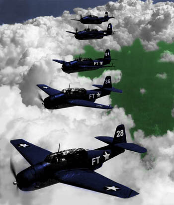
The five avengers lost on December 5th, 1945 are sometimes known as "The Lost Squadron." (Copyright Lee Krystek, 2011)
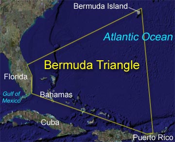
The Bermuda Triangle (sometimes also referred to as the Devil's Triangle) is a stretch of the Atlantic Ocean bordered by a line from Florida to the islands of Bermuda, to Puerto Rico and then back to Florida. It is one of the biggest mysteries of our time - that perhaps isn't really a mystery.
The term "Bermuda Triangle" was first used in an article written by Vincent H. Gaddis for Argosy magazine in 1964. In the article, Gaddis claimed that in this strange sea a number of ships and planes had disappeared without explanation. Gaddis wasn't the first one to come to this conclusion, either. As early as 1952, George X. Sands, in a report in Fate magazine, noted what seemed like an unusually large number of strange accidents in that region.
In 1969 John Wallace Spencer wrote a book called Limbo of the Lost specifically about the Triangle and, two years later, a feature documentary on the subject, The Devil's Triangle, was released. These, along with the bestseller The Bermuda Triangle, published in 1974, permanently registered the legend of the "Hoodoo Sea" within popular culture.
Why do ships and planes seem to go missing in the region? Some authors suggested it may be due to a strange magnetic anomaly that affects compass readings (in fact they claim Columbus noted this when he sailed through the area in 1492). Others theorize that methane eruptions from the ocean floor may suddenly be turning the sea into a froth that can't support a ship's weight so it sinks (though there is no evidence of this type of thing happening in the Triangle for the past 15,000 years). Several books have gone as far as conjecturing that the disappearances are due to an intelligent, technologically advanced race living in space or under the sea.

Kusche's Theory
In 1975 Larry Kusche, a librarian at Arizona State University, reached a totally different conclusion. Kusche decided to investigate the claims made by these articles and books. What he found he published in his own book entitled The Bermuda Triangle Mystery-Solved. Kusche had carefully dug into records other writers had neglected. He found that many of the strange accidents were not so strange after all. Often a Triangle writer had noted a ship or plane had disappeared in "calms seas" when the record showed a raging storm had been in progress. Others said ships had "mysteriously vanished" when their remains had actually been found and the cause of their sinking explained. In one case a ship listed missing in the Triangle actually had disappeared in the Pacific Ocean some 3,000 miles away! The author had confused the name of the Pacific port the ship had left with a city of the same name on the Atlantic coast.
More significantly, a check of Lloyd's of London's accident records by the editor of Fate in 1975 showed that the Trianglewas no more dangerous than any other part of the ocean. U.S. Coast Guard records confirmed this and since that time no good arguments have ever been made to refute those statistics. So many argue that the Bermuda Triangle mystery has disappeared, in the same way many of its supposed victims vanished.

Even though the Bermuda Triangle isn't a true mystery, this region of the sea certainly has had its share of marine tragedy. This region is one of the heaviest traveled areas of ocean in the world. Both small boats and commercial ships ply its waters along with airliners, military aircraft and private planes as they come to and from both the islands and more distant ports in Europe, South America and Africa. The weather in this region can make traveling hazardous also. The summer brings hurricanes while the warm waters of the Gulf Stream promote sudden storms. With this much activity in a relatively small region it isn't surprising that a large number of accidents occur. Some of the ones commonly connected to the Triangle story are:
The USS Cyclops Sinking
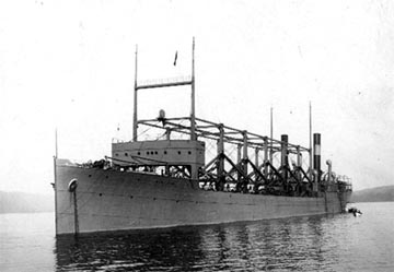
One of the first stories connected to the Triangle legend and the most famous ship lost in the region was the USS Cyclops which disappeared in 1918. The 542 foot long Cyclops was launched in 1910 and served as a collier ( a ship that carries coal) for the U.S. Navy during World War I. The vessel was on its way from Bahia, Salvador, to Baltimore, Maryland, but never arrived. After it had made an unscheduled stop at Barbados on March 3rd and 4th to take on additional supplies, it disappeared without a trace. No wreckage from the ship was ever found and no distress signal was received. The deaths of the 306 crew and passengers of the USS Cyclops remains the single largest loss of life in U.S. Naval history not directly involving combat.

The USS Cyclops in a 1911 photograph. (USN Photo)
While the sinking of the Cyclops remains a mystery, the incident could have happened anywhere between Barbados and Baltimore, not necessarily in the Bermuda Triangle. Proponents of the Bermuda Triangle theory point to the lack of a distress call as evidence of a paranormal end for the vessel, but the truth is that wireless communications in 1918 were unreliable and it would not have been unusual for a rapidly-sinking vessel to not have had a chance to send a successful distress call before going under.
SS Marine Sulphur Queen Vanishes
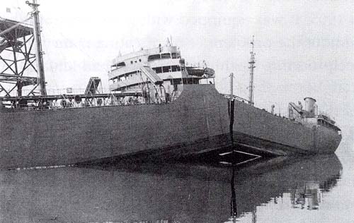
The SS Marine Sulphur Queen, a tanker ship carrying molten sulphur, disappeared off the southern coast of Florida in 1963. The crew of 39 was all lost and no wreckage from the tanker was ever found. While the disappearance of the ship is mentioned in several books about the Triangle, authors don't always include that the Coast Guard concluded that the vessel was in deplorable shape and should have never gone to sea at all. Fires erupted with regularity on the ship. Also, this class of vessel was known to have a "weak back", which means the keel would split when weakened by corrosion causing the ship to break in two. The ship's structure had been further compromised by a conversion from its original mission as an oil tanker to carrying molten sulphur. The conversion had left the vessel with an extremely high center of gravity, increasing the chance that it would capsize. The SS Marine Sulphur Queen was all-in-all a disaster waiting to happen and it seems unfair to blame its demise on the Bermuda Triangle.
.

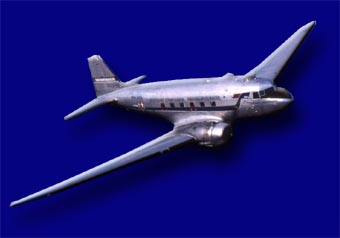
A Douglas DC-3 airliner of the same type as NC16002 (Wikipedia Commons)
The Disappearance of NC16002
NC16002 was a DC-3 passenger plane that vanished on the night of December 28, 1948, during a flight from San Juan, Puerto Rico, to Miami, Florida. The weather was fine with high visibility and the flight was, according to the pilot, within 50 miles of Miami when it disappeared with its three crew members and twenty-nine passengers. Though no probable cause for the loss was determined by the official investigation, it is known that the plane's batteries were not fully charged on takeoff and this may have interfered with communications during the flight. A message from Miami to the plane that the direction of the wind had changed may have not been received by the pilot, causing him to fly up to fifty miles off course.
The Fate of Flight 19
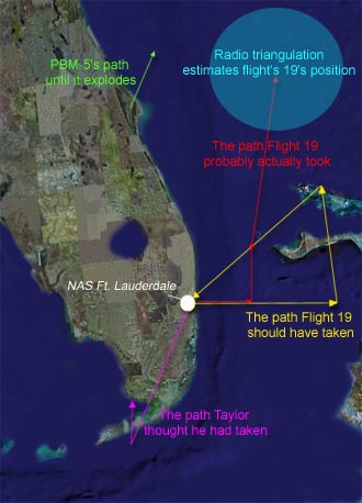
The tale of Flight 19 started on December 5th, 1945. Five Avenger torpedo bombers lifted into the air from the Naval Air Station at Fort Lauderdale, Florida, at 2:10 in the afternoon. It was a routine practice mission and the flight was composed of all students except for the Commander, a Lt. Charles Taylor.
The mission called for Taylor and his group of 13 men to fly due east 56 miles to Hens and Chicken Shoals to conduct practice bombing runs. When they had completed that objective, the flight plan called for them to fly an additional 67 miles east, and then turn north for 73 miles and finally straight back to base, a distance of 120 miles. This course would take them on a triangular path over the sea.

About an hour and a half after the flight had left, Lt. Robert Cox at the base picked up a radio transmission from Taylor. Taylor indicated that his compasses were not working, but he believed himself to be somewhere over the Florida Keys (the Keys are a long chain of islands south of the Florida mainland). Cox urged him to fly north toward Miami; if Taylor was sure the flight was over the Keys.
Planes today have a number of ways that they can check their current position including listening to a set of GPS (Global Positioning Satellites) in orbit around the earth. It is almost impossible for a pilot to get lost if he has the right equipment and uses it properly. In 1945, though, planes flying over water had to depend on knowing their starting point, how long and fast they had flown, and in what direction. If a pilot made a mistake with any of these figures, he was lost. Over the ocean there were no landmarks to set him right.
Navigational Confusion
Apparently Taylor had become confused at some point in the flight. He was an experienced pilot, but hadn't spent a lot of time flying east toward the Bahamas which was where he was going on that day. For some reason Taylor apparently thought the flight had started out in the wrong direction and had headed south toward the Keys, instead of east. This thought was to color his decisions throughout the rest of the flight with deadly results.

The more Taylor took his flight north to try to get out of the Keys, the further out to sea the Avengers actually traveled. As time went on, snatches of transmissions were picked up on the mainland indicating the other Flight 19 pilots were trying to get Taylor to change course. "If we would just fly west," one student told another, "we would get home." He was right
By 4:45 P.M. it was obvious to the people on the ground that Taylor was hopelessly lost. He was urged to turn control of the flight over to one of his students, but apparently he didn't. As it grew dark, communications deteriorated. From the few words that did get through it was apparent Taylor was still flying north and east, the wrong direction.
At 5:50 P.M. the ComGulf Sea Frontier Evaluation Center managed get a fix on Flight 19's weakening signals. It was apparently east of New Smyrna Beach, Florida. By then communications were so poor that this information could not be passed to the lost planes.
At 6:20 a Dumbo flying boat was dispatched to try and find Flight 19 and guide it back. Within the hour two more planes, Martin Mariners, joined the search. Hope was rapidly fading for Flight 19 by then. The weather was getting rough and the Avengers were very low on fuel.
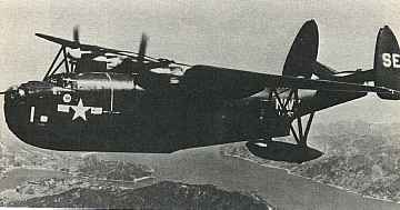
Two Martin Mariners were supposed to rendezvous at the search zone. The second one, designated Training 49, never showed up, joining the 5 Avengers as "missing."
The last transmission from Flight 19 was heard at 7:04 P.M. Planes searched the area through the night and the next day. There was no sign of the Avengers.
Nor did the authorities really expect to find much. The Avengers, crashing when their fuel was exhausted, would have been sent to the bottom in seconds by the 50 foot waves of the storm. As one of Taylor's colleagues noted, "...they didn't call those planes 'Iron Birds' for nothing. They weighed 14,000 pounds empty. So when they ditched, they went down pretty fast."
 
A Mariner similar to Training 49 (USN Photo)
What happened to the missing Martin Mariner? Well, the crew of the SS Gaines Mill observed an explosion over the water shortly after the Mariner had taken off. They headed toward the site and there they saw what looked like oil and airplane debris floating on the surface. None of it was recovered because of the bad weather, but there seems little doubt this was the remains of the Mariner. The plane had a reputation as being a "flying bomb" which would burst into flame from even a single, small spark. Speculation is that one of 22 men on board, unaware that the unpressurized cabin contained gas fumes, lit a cigarette, causing the explosion.
Missing Avengers become the Triangle's "Lost Squadron"
So how did this tragedy turn into a Bermuda Triangle mystery? The Navy's original investigation concluded the accident had been caused by Taylor's navigational confusion. According to those that knew him he was a good pilot, but often navigated "flying by the seat of his pants" and had gotten lost in the past. Taylor's mother refused to accept that and finally got the Navy to change the report to read that the disaster was for "causes or reasons unknown." This may have spared the woman's feelings, but blurred the actual facts.
The saga of Flight 19 is probably the most repeated story about the Bermuda Triangle. Vincent Gaddis put the tale into the same Argosy magazine article where he coined the term "Bermuda Triangle" in 1964 and thetwo have been connected ever since. The planes and their pilots even found their way into the science fiction film classic, Close Encounters of the Third Kind.
Where is Flight 19 now? Well, in 1991 five Avengers were found in 750 feet of water off the coast of Florida by the salvage ship Deep Sea. Examination of the plane's ID numbers, however, showed that they were not from Flight 19 (as many as 139 Avengers were thought to have gone into the water off the coast of Florida during the war). It seems the final resting place of the lost squadron and their crews is still a real Bermuda Triangle mystery.
A sister tanker to SS Marine Sulphur Queen which suffered a failure of the keel and split in two.

Kamis, 08 Mei 2014

History of Barcelona FC

FOOTBALL

History of FC Barcelona

On November 29, 1899, Hans Gamper founded Futbol Club Barcelona, along with eleven other enthusiasts of 'foot-ball', a game that was still largely unknown in this part of the world
He could never have imagined the magnitude of what that initiative would eventually develop into. Over more than one hundred years of history, FC Barcelona has grown spectacularly in every area and has progressed into something much greater than a mere sports club, turning Barça’s ‘more than a club’ slogan into a reality.
Barça has become, for millions of people all around the world, a symbol of their identity, and not just in a sporting sense, but also in terms of society, politics and culture. Throughout the most difficult of times, Barça was the standard that represented Catalonia and the Catalan people's desire for freedom, a symbolism that has continued to be closely linked to the idiosyncrasy of the Club and its members to this day. Within the context of Spain, Barça is seen as an open and democratic club. And all around the world, Barça is identified with caring causes, and most especially children through its sponsorship agreement with Unicef.
For a whole century, FC Barcelona has passed through moments of glory and pain, periods of brilliance and other less successful ones, epic victories and humbling defeats. But all these different moments have helped define the personality of a Club that, due to its peculiar nature, is considered unique in the world.
With over one hundred years of history, there have naturally been many different periods, both in a social and a sporting sense. In the early years (1899-1922) , from the foundation of the club to the construction of Les Corts stadium, Barça was a club that had to distinguish itself from all the other football teams in Barcelona, to the point that it would come to be identified with the city as a whole. Barça soon became the leading club in Catalonia, and also associated itself with the increasingly growing sense of Catalan national identity.
From Les Corts to the Camp Nou (1922-1957), the club went through contrasting periods. Its membership reached 10,000 for the first time, while football developed into a mass phenomenon and turned professional, and these were the years of such legendary figures as Alcántara and Samitier. But due to material difficulties and the political troubles of the Spanish Civil War and post-war period, the club was forced to overcome several adverse circumstances, including the assassination of president Josep Sunyol in 1936, the very person who had propagated the slogan ‘sport and citizenship'. But the club survived, and a period of social and sporting recovery materialised in the form of the Camp Nou, coinciding with the arrival of the hugely influential Ladislau Kubala.
From the construction of the Camp Nou to the 75th anniversary (1957-1974) , Barça suffered mediocre results but was consolidated as an entity, with a constantly increasing membership and the slow but steady recovery, in the face of adversity, of its identity. A very clear sensation that was manifested for the first time ever in the words ‘Barça, more than a club’ proclaimed by president Narcís de Carreras. The board presided by Agustí Montal brought a player to Barcelona who would change the history of the club, Johan Cruyff.
From the 7th anniversary to the European Cup (1974-1992) the club saw the conversion of football clubs to democracy, the start of Josep Lluís Núñez’s long presidency, the extension of the Camp Nou on occasion of the 1982 World Cup and the Cup Winners Cup triumph in Basle (1979), a major success not just in a sporting sense but also in a social one, with an enormous and exemplary expedition of Barça supporters demonstrating to Europe the unity of the Barcelona and Catalan flags. Cruyff returned, this time as coach, and created what would come to be known as the 'Dream Team' (1990-1994), whose crowning glory was the conquest of the European Cup at Wembley (1992), thanks to Koeman’s famous goal. International Dominance. From Wembley to Abu Dhabi (1992-2009) was when the club’s most recent developments occurred in between its three greatest achievements, becoming champions of Europe. Josep Lluís Núñez’s long presidency came to an end, and the club displayed its finest potential during the celebrations of the club Centenary. Following on from Joan Gaspart (2000-2003), the June 2003 election brought Joan Laporta into office, and the start of new social expansion, reaching 172,938 members, and more successes on the pitch, including four league titles, the Champions League titles won in Paris and Rome and the FIFA Club World Cup.
In the season 2008-09 the arrival of Josep Guardiola as first team coach brought new energy to the club and they recorded the most successful season in their entire history winning the six titles that will be forever burned into the memories of all Barça fans. Success on the field has helped the club expand its social role and heighten its media profile. In the 2009/10 season, Guardiola’s second in charge, the Liga title was won for the second year in a row, and the twentieth on club history, setting a new record of 99 points in the process. The title was not decided until the very last day, with a game against Valladolid, and the celebrations went ahead that very same evening in the company of the fans at the Camp Nou.The grandeur of Futbol Club Barcelona is explained, among many other factors, by its impressive honours list. Very few clubs anywhere in the world have won so many titles. The Intercontinental Cup is the only major football trophy that has never made its way into the club museum, where the club's greatest pride and joy remain the three European Cup titles won in Wembley (1992) Paris (2006), Rome (2009) and the FIFA Club World Cup in 2009.
Apart from winning Europe’s top title,, the Club also has the honour of being the only one to have appeared in every single edition of European club competition since the tournaments were first created back in 1955. Barcelona's many achievements in Europe include being considered 'King of the Cup Winners Cup', having won that title a record four timesIn addition, FC Barcelona also won three Fairs Cups (the tournament now known as the UEFA Cup) in 1958, 1960 and 1966. In 1971, Barça won that trophy outright in a match played between themselves, as the first ever winners of the competition, and Leeds United, as the last.

Taman Sari

Tamansari Tamansari Tamansari Tamansari

TAMAN SARI

Alamat: Jl. Taman, Kraton, Yogyakarta 55133, Indonesia
Koordinat GPS: S7°48'36.4" E110°21'34.2"
Gemericik air, keindahan arsitekturnya yang kuno, dan pemandangan yang menakjubkan membuat Taman Sari sangat mempesona. Lorong-lorong dan bangunannya menjadikan Taman Sari penuh rahasia yang akan terus dikuak.

TAMAN SARI
Istana Air Penuh Keindahan dan Rahasia

Masa setelah Perjanjian Giyanti, Pangeran Mangkubumi membangun keraton sebagai pusat pemerintahan Kasultanan Ngayogyakarta Hadiningrat. Pangeran Mangkubumi yang kemudian bergelar Sultan Hamengku Buwono I membangun keraton di tengah sumbu imajiner yang membentang di antara Gunung Merapi dan Pantai Parangtritis. Titik yang menjadi acuan pembangunan keraton adalah sebuah umbul (mata air). Untuk menghormati jasa istri-istri Sultan karena telah membantu selama masa peperangan, beliau memerintahkan Demak Tegis seorang arsitek berkebangsaan Portugis dan Bupati Madiun sebagai mandor untuk membangun sebuah istana di umbul yang terletak 500 meter selatan keraton. Istana yang dikelilingi segaran (danau buatan) dengan wewangian dari bunga-bunga yang sengaja ditanam di pulau buatan di sekitarnya itu sekarang dikenal dengan nama Taman Sari.
"Dari atas Gapura Panggung ini Sultan biasa menyaksikan tari-tarian di bawah sana. Bangunan-bangunan di sampingnya merupakan tempat para penabuh dan di tengah-tengah biasa didirikan panggung tempat para penari menunjukkan kepiawaian dan keluwesan mereka," terang seorang pemandu ketika YogYES memasuki Taman Sari. Dari Gapura Panggung, pemandu membawa YogYES masuk ke area yang dulunya hanya diperbolehkan untuk Sultan dan keluarganya, kolam pemandian Taman Sari. Gemericik air langsung menyapa. Airnya yang jernih berpadu apik dengan tembok-tembok krem gagah yang mengitarinya. Kolam pemandian di area ini dibagi menjadi tiga yaitu Umbul Kawitan (kolam untuk putra-putri Raja), Umbul Pamuncar (kolam untuk para selir), dan Umbul Panguras (kolam untuk Raja).

Sebuah periuk tempat istri-istri Sultan bercermin masih utuh berdiri ketika YogYES memasuki menara tempat pribadi Sultan. Ornamen yang menghiasi periuk memberi kesan glamor terhadap benda yang terletak di samping lemari pakaian Sultan tersebut. Bisa dibayangkan, 200 tahun lalu seorang wanita cantik menunggu air di periuk ini hingga tenang lalu dia menundukkan kepalanya, memperbaiki riasan dan sanggulnya, memperindah raganya sembari bercermin. Selain periuk dan kamar pribadi Sultan, di menara yang terdiri dari tiga tingkat ini ada tangga dari kayu jati yang masih utuh terawat sehingga memberi kesan antik bagi siapa pun yang melihatnya. Naik ke tingkat paling atas, pantulan mentari dari kolam di bawahnya dan seluruh area Taman Sari terlihat dengan jelas. Mungkin dahulu Sultan juga menikmati pemandangan dari atas sini, pemandangan Taman Sari yang masih lengkap dengan danau buatannya dan bunga-bunga yang semerbak mewangi.
Selepas menikmati pemandangan dari atas menara, pemandu lalu membawa YogYES menuju Gapura Agung, tempat kedatangan kereta kencana yang biasa dinaiki Sultan dan keluarganya. Gapura yang dominan dengan ornamen bunga dan sayap burung ini menjadi pintu masuk bagi keluarga Sultan yang hendak memasuki Taman Sari. Pesanggrahan tepat di selatan Taman Sari menjadi tujuan berikutnya. Sebelum berperang, Sultan akan bersemedi di tempat ini. Suasana senyap dan hening langsung terasa ketika YogYES masuk. Di sini, Sultan pastilah memikirkan berbagai cara negosiasi dan strategi perang supaya kedaulatan Keraton Yogyakarta tetap terjaga. Areal ini juga menjadi tempat penyimpanan senjata-senjata, baju perang, dan tempat penyucian keris-keris jaman dahulu. Pelatarannya biasa digunakan para prajurit berlatih pedang.
YogYES pun berpisah dengan pemandu di depan Gapura Agung. Namun, ini bukan berarti perjalanan terhenti karena masih ada beberapa tempat yang harus disinggahi seperti Sumur Gumuling dan Gedung Kenongo. Untuk menuju tempat tersebut, Anda harus melewati Tajug, lorong yang menghubungkan Taman Sari dengan keraton dan juga Pulo Kenongo. Lorong bawah tanah yang lebar ini memang untuk berjaga-jaga apabila keraton dalam keadaan genting. Ruang rahasia banyak tersembunyi di tempat ini. Keluar dari Tajug, Anda akan melihat bekas dari Pulo Kenongo yang dulunya banyak ditumbuhi bunga kenanga yang menyedapkan Taman Sari. YogYES pun menuju Sumur Gumuling, masjid bawah tanah tempat peribadatan raja dan keluarga. Bangunan dua tingkat yang didesain memiliki sisi akustik yang baik. Jadi, pada zaman dahulu, ketika imam mempimpin shalat, suara imam dapat terdengar dengan baik ke segala penjuru. Sekarang pun, hal itu masih dapat dirasakan. Suara percakapan dari orang-orang yang ada jauh dari kita terasa seperti mereka sedang berada di samping kita. Selain itu, Untuk menuju ke pusat masjid ini, lagi-lagi harus melewati lorong-lorong yang gelap. Sesampainya di tengah masjid yang berupa tempat berbentuk persegi dengan 5 anak tangga di sekelilingnya, keagungan semakin terasa. Ketika menengadahkan kepala terlihat langit biru. Suara burung yang terdengar dari permukiman penduduk di area Taman Sari semakin menambah tenteram suasana.
Persinggahan terakhir adalah Gedung Kenongo. Gedung yang dulunya digunakan sebagai tempat raja bersantap ini merupakan gedung tertinggi se-Taman Sari. Di tempat ini Anda dapat menikmati golden sunset yang mempesona. Keseluruhan Taman Sari pun bisa dilihat dari sini, seperti Masjid Soko Guru di sebelah timur dan ventilasi-ventilasi dari Tajug. Puas dengan kesegaran air dari Taman Sari, langit akan menyapa. Pemandangan yang indah sekaligus mempesona ditawarkan Taman Sari. Pesona air yang apik berpadu dengan tembok-tembok bergaya campuran Eropa, Hindu, Jawa, dan China menjadi nilai yang membuat Taman Sari tak akan terlupakan.
Jam Buka: Senin - Minggu, pukul 09.00 - 15.30 WIB
Tiket:
  • Wisatawan Domestik: Rp 3.000
  • Wisatawan Mancanegara: Rp 7.000
  • Guide: nego (Rp 10.000 - Rp 20.000)
Keterangan:
harga tiket diperoleh pada perjalanan bulan Januari 2012. Untuk tarif pemandu bervariasi, tergantung kesepakatan bersama.

Sejarah Komodo

  1. Komodo

    Nama komodo pasti sudah tidak asing lagi ditelinga kita. Hewan asli indonesia yang berasal dari pulau komodo ini ternyata merupakan reptil berbisa paling ganas di dunia dengan virus-virus yang dapat melumpuhkan mangsa dengan sangat cepat. Terbukti dari beberapa kasus penyerangan yang terjadi akhir-akhir ini.Sebuah studi baru telah menunjukkan bahwa Komodo (Varamus komodoensis) yang hidup di Taman Nasional Komodo, Kabupaten Manggarai Barat, Nusa Tenggara Timur, merupakan reptil berbisa paling mematikan di dunia saat ini.Rahasia kemampuan membunuh mangsa dari hewan reptil Komodo ternyata terletak pada kombinasi kekuatan gigitannya dan racun berbisa yang dikeluarkan ribuan kelenjar-kelenjar yang terletak digusinya, yang dikeluarkan bersamaan dengan gigitan.Temuan ini mematahkan teori sebelumnya yang mengatakan bahwa kemampuan membunuh mangsa dari Komodo terletak pada air liurnya yang mengandung puluhan bakteria mematikan, yang dikeluarkan bersamaan dengan gigitan.Teori ini didasarkan pengamatan bahwa mangsa Komodo biasanya mati setelah beberapa jam mendapat gigitan yang berdarah, dan kemudian akan mati membusuk.Tak adanya taring yang kuat pada gigi Komodo, juga menunjukkan Komodo tak sepenuhnya binatang pemangsa Carnivora, sehingga sejak lama menjadi penelitian apa rahasia Komodo mematahkan mangsanya. Namun kini dengan teori diatas, sedikitnya tersedia sebuah jawaban rahasia kekuatan mematikan dari Komodo. Seorang peneliti yaitu Dr Bryan Fry dari Universitas Melbourne, Australia, yang menemukan teori ini, melakukan penelitian dengan menggunakan foto medis atau rontgen pada jaringan kepala Komodo.
    Ia menemukan adanya ribuan kelenjar kompleks yang berujung diantara deretan gigi-giginya, yang mempunyai kemampuan mengeluarkan bisa beracun yang mematikan.
    “Reptil ini biasanya menggigit mangsanya, dan kemudian meninggalkan mangsa yang berdarah hingga mati akibat luka yang mematikan. Kami sekarang tahu bahwa itu disebabkan oleh kombinasi kekuatan gigi dan kelenjar berbisa yang mematikan mangsa,” ujar Dr Fry.
    “Kombinasi gigitan dan bisa racun ini membuat Komodo sedikit melakukan kontak dengan mangsanya, ia cukup melukai dan menyeburkan racun, kemudian meninggalkannya. Membuat Komodo bisa menangkap mangsa yang lebih besar, tanpa harus lama bertempur yang juga akan berbahaya bagi dirinya,” ujar Dr Fry.
    Dr Fry kemudian juga melakukan analisa dengan menggunakan simulasi komputer, untuk mengukur tingkat ketajaman mematikan dari gigitan Komodo dibandingkan dengan gigitan binatang Carnivora lain seperti Buaya. Ternyata gigitan Komodo jauh lebih lemah dibandingkan dengan kemampuan gigitan Buaya.
    Dari sini timbul hipotesa tak mungkin Komodo mematikan mangsanya hanya mengandalkan pada gigitan, seperti umumnya Carnivora lain. Dari uji resonansi magnetik diperoleh gambaran adanya kelenjar komplek diantara gigi-gigi Komodo yang mengasilkan cairan bisa beracun, yang ditinggalkan bersama gigitan Komodo. “Kami percaya hewan reptil jenis Komodo mampu melumpuhkan mangsanya dengan bisa beracun yang meningkatkan kerusakan akibat gigitan gigi,” ujar Dr Fry.
    Para peneliti kini sedang meneruskan risetnya untuk mengetahui kandungan dan komposisi molekul bisa beracun yang dikeluarkan kelenjar Komodo. Efek dari bisa beracun juga diuji oleh para peneliti, yang menampakkan kesamaan pengaruh dengan bisa beracun yang dikeluarkan oleh kelompok ular, yang biasanya membuat shock mangsa.
    Hal ini bisa menerangkan kenapa mangsa Komodo biasanya menjadi diam saja setelah mendapatkan gigitan, karena menahan sakit akibat pengaruh bisa. Setelah digigit, mangsa biasanya juga mengeluarkan darah sebanyak-banyaknya.
    Para peneliti kemudian juga memeriksa kerangka fosil hewan reptil Komodo yang termasuk binatang purbakala ini, dan menemukan ciri-ciri kerangka binatang yang menggunakan bisa beracun untuk melumpuhkan mangsanya.
    Penelitian ini kemudian menyimpulkan bahwa kadal raksasa sepanjang 7 meter ini adalah binatang berbisa terbesar yang pernah hidup di muka bumi.
    Berhati -hatilah jika Anda berada dekat dengan Reptil yang satu ini, karena bisa jadi Anda menjadi sasaran keganasannya karena jika tergigit, dipastikan korbannya tidak akan bertahan lama karena virusnya yang mematikan.
    Ada baiknya anda menghindar saja jika bertemu hewan reptil yang bernama komodo, demi keselamatan anda.]
    Komodo atau Biawak Komodo (Varanus komodoensis), merupakan spesies reptil terbesar di dunia yang terdapat di pulau Komodo, Rinca, Flores, Gili Motang, dan Gili Dasami di Nusa Tenggara, Indonesia. Komodo yang ditemukan pertama kali oleh peneliti barat pada tahun 1910.
    Komodo (Varanus komodoensis) merupakan satu diantara 3 satwa nasional Indonesia. Komodo sebagai satwa bangsa mendampingi burung elang jawa (satwa langka) dan ikan siluk merah (satwa pesona). Komodo juga ditetapkan sebagai fauna identitas provinsi Nusa Tenggara Timur.
    Komodo dragon, biawak terbesar dan terunikKomodo dalam bahasa latin disebut sebagai Varanus komodoensis. Oleh masyarakat setempat biasa dinamakan Ora. Beberapa nama lain komodo seperti Biawak Komodo, Komodo Dragon, Komodo Island Monitor, dan Komodo Monitor.
    Habitat komodo yang hanya terdapat di beberapa pulau di Nusa Tenggara yang termasuk dalam wilayah Taman Nasional Komodo juga mendapat apresiasi di dunia internasional dengan lolosnya menjadi salah satu dari 28 finalis New 7 Wonders of Nature.
    Ciri-ciri dan Perilaku Komodo. Komodo (Varanus komodoensis) menjadi reptil terbesar di dunia yang mempunyai panjang tubuh mencapai 3 meter dan berat 70 kg. Spesimen liar terbesar yang ditemukan mempunyai panjang 3.13 meter dengan berat 166 kilogram (termasuk berat makanan yang belum dicerna di dalam perutnya). Meskipun untuk spesies komodo yang hidup di penangkaran mampu memiliki berat yang lebih besar.
    Komodo memiliki ekor yang sama panjang dengan tubuhnya, dan sekitar 60 buah gigi yang bergerigi tajam masing-masing sepanjang sekitar 2.5 cm, yang kerap berganti. Pada giginya terdapat jaringan gingiva yang sering tercabik saat makan. Karenanya sering kali ditemua sedikit darah pada air liur komodo. Air liur ini menciptakan lingkungan pertumbuhan yang ideal bagi sejenis bakteri mematikan yang hidup di mulut komodo.
    Lidah komodo panjang, berwarna kuning dan bercabang. Komodo jantan berukuran lebih besar daripada komodo betina, dengan warna kulit dari abu-abu gelap sampai merah batu bata. Sementara kulit komodo betina berwarna hijau buah zaitun, dan memiliki potongan kecil kuning pada tenggorokannya. Komodo muda lebih berwarna, dengan warna kuning, hijau dan putih pada latar belakang hitam.
    Komodo tak memiliki indera pendengaran, meski memiliki lubang telinga. Biawak ini mampu melihat hingga sejauh 300 m, namun kurang baik melihat di kegelapan malam. Komodo menggunakan lidahnya untuk mendeteksi rasa dan mencium stimuli, seperti reptil lainnya, dengan indera vomeronasal memanfaatkan organ Jacobson, suatu kemampuan yang dapat membantu navigasi pada saat gelap. Dengan bantuan angin dan kebiasaannya menelengkan kepalanya ke kanan dan ke kiri ketika berjalan, komodo dapat mendeteksi keberadaan daging bangkai sejauh 4—9.5 kilometer.
    Komodo mampu berdiri di atas kedua kakinyaMangsa biawak komodo amat bervariasi, mencakup aneka avertebrata, reptil lain (termasuk pula komodo yang bertubuh lebih kecil), burung dan telurnya, mamalia kecil, monyet, babi hutan, kambing, rusa, kuda, dan kerbau. Komodo muda memangsa serangga, telur, cicak, dan mamalia kecil.
    Biawak komodo (Varanus komodoensis) aktif pada siang hari, walaupun terkadang aktif juga pada malam hari. Komodo adalah binatang yang penyendiri, berkumpul bersama hanya pada saat makan dan berkembang biak. Reptil terbesar di dunia ini dapat berlari cepat hingga 20 kilometer per jam pada jarak dekat, dapat berenang menyelam hingga sedalam 4.5 meter. Komodo juga pandai memanjat pohon menggunakan cakar mereka yang kuat. Untuk menangkap mangsa yang berada di luar jangkauannya, komodo dapat berdiri dengan kaki belakangnya dan menggunakan ekornya sebagai penunjang tubuh.
    Habitat dan Persebaran. Komodo atau Ora (Varanus komodoensis) secara alami terdapat di pulau Komodo, Flores dan Rinca, Gili Motang, dan Gili Dasami di Nusa Tenggara. Pulau-pulau tersebut termasuk dalam wilayah Taman Nasional pulau Komodo yang merupakan salah satu finalis New 7 Wonders of Nature.
    Komodo hidup di padang rumput kering terbuka, sabana dan hutan tropis pada ketinggian rendah, biawak terbesar ini menyukai tempat panas dan kering. Untuk tempat berlindung, komodo menggali lubang selebar 1–3 meter. Karena besar tubuhnya dan kebiasaan tidur di dalam lubang, komodo dapat menjaga panas tubuhnya selama malam hari dan mengurangi waktu berjemur pada pagi selanjutnya. Tempat-tempat sembunyi komodo ini biasanya berada di daerah gumuk atau perbukitan dengan semilir angin laut, terbuka dari vegetasi, dan di sana-sini berserak kotoran hewan penghuninya.
    Konservasi dan Populasi. Biawak komodo merupakan spesies yang rentan terhadap kepunahan sehingga oleh IUCN Redlist dikatagorikan dalam status konservasi Rentan (Vurnerable). CITES (the Convention on International Trade in Endangered Species) telah menetapkan bahwa perdagangan komodo, kulitnya, dan produk-produk lain dari hewan ini adalah ilegal.
    Sekitar 4.000–5.000 ekor komodo diperkirakan masih hidup di alam liar. Populasi ini terbatas menyebar di pulau-pulau Rinca (1.300 ekor), Gili Motang (100), Gili Dasami (100), Komodo (1.700), dan Flores (mungkin sekitar 2.000 ekor, Meski demikian, ada keprihatinan mengenai populasi ini karena diperkirakan dari semuanya itu hanya tinggal 350 ekor betina yang produktif dan dapat berbiak.
    Komodo di tepi pantai Bertolak dari kekhawatiran ini, sejak tahun 1980 Pemerintah Indonesia menetapkan berdirinya Taman Nasional Komodo untuk melindungi populasi komodo dan ekosistemnya di beberapa pulau termasuk Komodo, Rinca, dan Padar. Belakangan ditetapkan pula Cagar Alam Wae Wuul dan Wolo Tado di Pulau Flores untuk membantu pelestarian komodo.
    Aktivitas vulkanis, gempa bumi, kerusakan habitat, kebakaran, berkurangnya mangsa, meningkatnya pariwisata, dan perburuan gelap; semuanya menyumbang pada status rentan yang disandang komodo.
    Tentang komodo ini memang tidak ada kata lain selain satwa yang amat unik yang telah dianugerahkan kepada bumi Indonesia. Maka sudah tidak ada tawar menawar lagi kita musti melindunginya. Dan kini, ketika terbuka kesempatan akan pengakuan dunia pada keunikan Taman Nasional Komodo sebagai habitat alami komodo dragon satu yang musti kita lakukan, dukung komodo sebagai salah satu keajaiban dunia.
    Klasifikasi ilmiah: Kerajaan: Animalia; Filum: Chordata; Kelas: Reptilia; Ordo: Squamata; Upaordo: Autarchoglossa; Famili: Varanidae; Genus: Varanus; Spesies: Varamus komodoensis

Rabu, 07 Mei 2014

Keraton Yogyakarta

Keraton Ngayogyakarta Hadiningrat atau Keraton Yogyakarta merupakan istana resmi Kesultanan Ngayogyakarta Hadiningrat yang kini berlokasi di Kota Yogyakarta, Daerah Istimewa Yogyakarta, Indonesia. Walaupun kesultanan tersebut secara resmi telah menjadi bagian Republik Indonesia pada tahun 1950, kompleks bangunan keraton ini masih berfungsi sebagai tempat tinggal sultan dan rumah tangga istananya yang masih menjalankan tradisi kesultanan hingga saat ini. Keraton ini kini juga merupakan salah satu objek wisata di Kota Yogyakarta. Sebagian kompleks keraton merupakan museum yang menyimpan berbagai koleksi milik kesultanan, termasuk berbagai pemberian dari raja-raja Eropa, replika pusaka keraton, dan gamelan. Dari segi bangunannya, keraton ini merupakan salah satu contoh arsitektur istana Jawa yang terbaik, memiliki balairung-balairung mewah dan lapangan serta paviliun yang luas.[1]

Sejarah


Sultan Hamengkubuwono VIII menerima kunjungan kehormatan Gubernur Jenderal Hindia Belanda Bijleveld di Keraton Yogyakarta, sekitar tahun 1937.
Keraton Yogyakarta mulai didirikan oleh Sultan Hamengku Buwono I beberapa bulan pasca Perjanjian Giyanti pada tahun 1755. Lokasi keraton ini konon adalah bekas sebuah pesanggarahan[2] yang bernama Garjitawati. Pesanggrahan ini digunakan untuk istirahat iring-iringan jenazah raja-raja Mataram (Kartasura dan Surakarta) yang akan dimakamkan di Imogiri. Versi lain menyebutkan lokasi keraton merupakan sebuah mata air, Umbul Pacethokan, yang ada di tengah hutan Beringan. Sebelum menempati Keraton Yogyakarta, Sultan Hamengku Buwono I berdiam di Pesanggrahan Ambar Ketawang yang sekarang termasuk wilayah Kecamatan Gamping Kabupaten Sleman[3].
Secara fisik istana para Sultan Yogyakarta memiliki tujuh kompleks inti yaitu Siti Hinggil Ler (Balairung Utara), Kamandhungan Ler (Kamandhungan Utara), Sri Manganti, Kedhaton, Kamagangan, Kamandhungan Kidul (Kamandhungan Selatan), dan Siti Hinggil Kidul (Balairung Selatan)[4][5]. Selain itu Keraton Yogyakarta memiliki berbagai warisan budaya baik yang berbentuk upacara maupun benda-benda kuno dan bersejarah. Di sisi lain, Keraton Yogyakarta juga merupakan suatu lembaga adat lengkap dengan pemangku adatnya. Oleh karenanya tidaklah mengherankan jika nilai-nilai filosofi begitu pula mitologi menyelubungi Keraton Yogyakarta. Dan untuk itulah pada tahun 1995 Komplek Keraton Ngayogyakarta Hadiningrat dicalonkan untuk menjadi salah satu Situs Warisan Dunia UNESCO.

Tata ruang dan arsitektur umum

Arsitek kepala istana ini adalah Sultan Hamengkubuwana I, pendiri Kesultanan Ngayogyakarta Hadiningrat. Keahliannya dalam bidang arsitektur dihargai oleh ilmuwan berkebangsaan Belanda, Theodoor Gautier Thomas Pigeaud dan Lucien Adam yang menganggapnya sebagai "arsitek" dari saudara Pakubuwono II Surakarta"[6]. Bangunan pokok dan desain dasar tata ruang dari keraton berikut desain dasar landscape kota tua Yogyakarta[7] diselesaikan antara tahun 1755-1756. Bangunan lain di tambahkan kemudian oleh para Sultan Yogyakarta berikutnya. Bentuk istana yang tampak sekarang ini sebagian besar merupakan hasil pemugaran dan restorasi yang dilakukan oleh Sultan Hamengku Buwono VIII (bertahta tahun 1921-1939).

Tata ruang


Koridor di Kedhaton dengan latar belakang Gedhong Jene dan Gedhong Purworetno
Dahulu bagian utama istana, dari utara keselatan, dimulai dari Gapura Gladhag di utara sampai di Plengkung[8] Nirboyo di selatan. Bagian-bagian utama keraton Yogyakarta dari utara ke selatan adalah: Gapura Gladag-Pangurakan; Kompleks Alun-alun Ler (Lapangan Utara) dan Mesjid Gedhe (Masjid Raya Kerajaan); Kompleks Pagelaran, Kompleks Siti Hinggil Ler, Kompleks Kamandhungan Ler; Kompleks Sri Manganti; Kompleks Kedhaton; Kompleks Kamagangan; Kompleks Kamandhungan Kidul; Kompleks Siti Hinggil Kidul (sekarang disebut Sasana Hinggil); serta Alun-alun Kidul (Lapangan Selatan) dan Plengkung Nirbaya yang biasa disebut Plengkung Gadhing[9][10].
Bagian-bagian sebelah utara Kedhaton dengan sebelah selatannya boleh dikatakan simetris. Sebagian besar bagunan di utara Kompleks Kedhaton menghadap arah utara dan di sebelah selatan Kompleks Kedhaton menghadap ke selatan. Di daerah Kedhaton sendiri bangunan kebanyakan menghadap timur atau barat. Namun demikian ada bangunan yang menghadap ke arah yang lain.
Selain bagian-bagian utama yang berporos utara-selatan keraton juga memiliki bagian yang lain. Bagian tersebut antara lain adalah Kompleks Pracimosono, Kompleks Roto Wijayan, Kompleks Keraton Kilen, Kompleks Taman Sari, dan Kompleks Istana Putra Mahkota (mula-mula Sawojajar kemudian di nDalem Mangkubumen). Di sekeliling Keraton dan di dalamnya terdapat sistem pertahanan yang terdiri dari tembok/dinding Cepuri dan Baluwerti. Di luar dinding tersebut ada beberapa bangunan yang terkait dengan keraton antara lain Tugu Pal Putih, Gedhong Krapyak, nDalem Kepatihan (Istana Perdana Menteri), dan Pasar Beringharjo.

Arsitektur umum


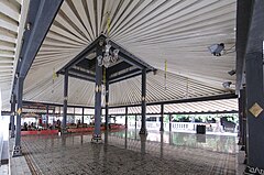
Bangsal Sri Manganti tempat pertunjukan tari dan seni karawitan gamelan di Kraton Yogyakarta.

Salah satu bangunan Tratag dalam kompleks keraton.
Secara umum tiap kompleks utama terdiri dari halaman yang ditutupi dengan pasir dari pantai selatan, bangunan utama serta pendamping, dan kadang ditanami pohon tertentu. Kompleks satu dengan yang lain dipisahkan oleh tembok yang cukup tinggi dan dihubungkan dengan Regol[11] yang biasanya bergaya Semar Tinandu[12] . Daun pintu terbuat dari kayu jati yang tebal. Di belakang atau di muka setiap gerbang biasanya terdapat dinding penyekat yang disebut Renteng atau Baturono. Pada regol tertentu penyekat ini terdapat ornamen yang khas.
Bangunan-bangunan Keraton Yogyakarta lebih terlihat bergaya arsitektur Jawa tradisional. Di beberapa bagian tertentu terlihat sentuhan dari budaya asing seperti Portugis, Belanda, bahkan Cina. Bangunan di tiap kompleks biasanya berbentuk/berkonstruksi Joglo atau derivasi/turunan konstruksinya. Joglo terbuka tanpa dinding disebut dengan Bangsal sedangkan joglo tertutup dinding dinamakan Gedhong (gedung). Selain itu ada bangunan yang berupa kanopi beratap bambu dan bertiang bambu yang disebut Tratag. Pada perkembangannya bangunan ini beratap seng dan bertiang besi.
Permukaan atap joglo berupa trapesium. Bahannya terbuat dari sirap, genting tanah, maupun seng dan biasanya berwarna merah atau kelabu. Atap tersebut ditopang oleh tiang utama yang di sebut dengan Soko Guru yang berada di tengah bangunan, serta tiang-tiang lainnya. Tiang-tiang bangunan biasanya berwarna hijau gelap atau hitam dengan ornamen berwarna kuning, hijau muda, merah, dan emas maupun yang lain. Untuk bagian bangunan lainnya yang terbuat dari kayu memiliki warna senada dengan warna pada tiang. Pada bangunan tertentu (misal Manguntur Tangkil) memiliki ornamen Putri Mirong, stilasi dari kaligrafi Allah, Muhammad, dan Alif Lam Mim Ra, di tengah tiangnya.
Untuk batu alas tiang, Ompak, berwarna hitam dipadu dengan ornamen berwarna emas. Warna putih mendominasi dinding bangunan maupun dinding pemisah kompleks. Lantai biasanya terbuat dari batu pualam putih atau dari ubin bermotif. Lantai dibuat lebih tinggi dari halaman berpasir. Pada bangunan tertentu memiliki lantai utama yang lebih tinggi[13]. Pada bangunan tertentu dilengkapi dengan batu persegi yang disebut Selo Gilang tempat menempatkan singgasana Sultan.
Tiap-tiap bangunan memiliki kelas tergantung pada fungsinya termasuk kedekatannya dengan jabatan penggunanya. Kelas utama misalnya, bangunan yang dipergunakan oleh Sultan dalam kapasitas jabatannya, memiliki detail ornamen yang lebih rumit dan indah dibandingkan dengan kelas dibawahnya. Semakin rendah kelas bangunan maka ornamen semakin sederhana bahkan tidak memiliki ornamen sama sekali. Selain ornamen, kelas bangunan juga dapat dilihat dari bahan serta bentuk bagian atau keseluruhan dari bangunan itu sendiri.[14]